


This year, Ukraine’s recent Independence Day was shadowed by a darker anniversary: the six-month mark since Russia invaded the country. While the Kremlin initially planned for a short, victorious war, the Ukrainian resistance proved stronger than expected.
As the brutal war is drawn out, the death toll climbs higher. To better understand how the war is progressing the Payne Institute’s Earth Observation Group has collected satellite images showing the light and fire patterns accompanying the military activity.
By using various satellite data science techniques, we are able to help inform countries in conflict or war in near real-time about the hazards they are facing. In the case of Russian attacks on Ukraine, we can identify explosions or fires geospatially, which can illustrate the incoming threat to infrastructure and people, and how defense strategies can be designed. While these images do not give sufficient detail to understand the exact nature of the arms being used, they can be derived through publicly available data sets, and can serve as an additional form of intelligence. By providing satellite data globally for issues as disperse as conflict, to illegal fishing, to forest fires and gas flares, our work helps governments and companies inform short-term responses and longer-scale decisions.
LIGHT AND MILITARY ACTIVITY*
Shortly after the initial invasion, Russian forces targeted Kyiv with intense military activity, but after weeks of fighting, Russia was still unable to gain control of the capital city.
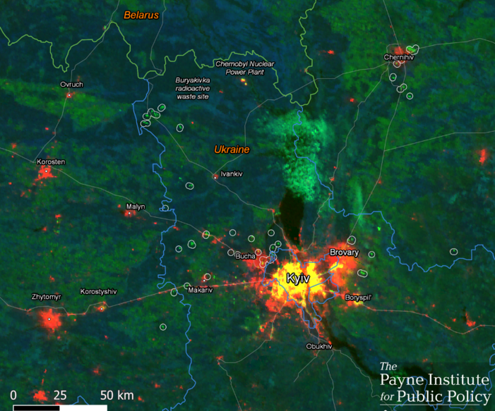
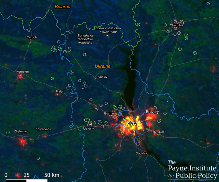
On Mar. 17, 2022 numerous fires were observed east and west of Kyiv and near Chernihiv. The number of fires detected increased significantly compared to the night before as seen in the images below, where the first image is from Mar. 16, 2022 and the second is from Mar. 17, 2022.
By late March 2022, the Russian Ministry of Defense announced it would turn its focus to “fully liberating” the Donbas region in eastern Ukraine and the activity in Kyiv was reduced in the following days. By mid-May 2022, cities near Kyiv showed a steady increase in lighting, indicating residents were beginning to return to their homes.
On Mar. 25, 2022, the day Russia announced a new focus on Donbas, the number of observed events near Kyiv were much fewer than previous days. Some larger events were observed near Chernihiv to the north, as seen below.
In mid-May, the lighting activity continued to grow in cities near Kyiv.
While military activity was reduced in Kyiv, it began to increase rapidly to the east. In early May, the Ukrainians launched a counteroffensive in the city of Kharkiv to push Russian forces back toward the border. Meanwhile, Russia was launching attacks on the Donbas region, which is made up of the Luhansk region and the Donetsk region. The two regions are occupied by large percentages of Russian-backed separatists who created a self-declared republic back in 2014.
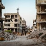
The siege of Mariupol, an important industrial and port city in the Donetsk region, quickly fell under Russian focus, and the brutal attacks left many citizens wounded or dead and buildings destroyed. Hundreds of Ukrainian soldiers and trapped citizens took refuge in the Azovstal Steel plant as the surrounding city fell to Russian control. The satellite image shows intensive activities around Kharkiv on May 11. The activity was also observed in the Donbas region, including in Mariupol where Russian forces continued air and artillery strikes on the Azovstal Iron and Steel Works plant.
On May 16, after two months of Russia besieging the city, the Ukrainians ended their defense of the steel plant. With the fall of Mariupol to Russia, soldiers seized control of the land bridge connected to Crimea across the southern coast of Ukraine. (May 16 does not have a clear observation from space).
In late May and early June, Russia continued to gradually capture towns and villages in the the Donbas region. Ukrainian forces were losing up to 100 soldiers a day in the eastern regions of the country, according to Ukrainian President Volodymyr Zelenskyy.
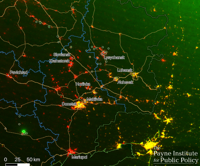
On May 29, the frontline military activity in the Donbas began to shift north to the city of Donetsk as pictured below.
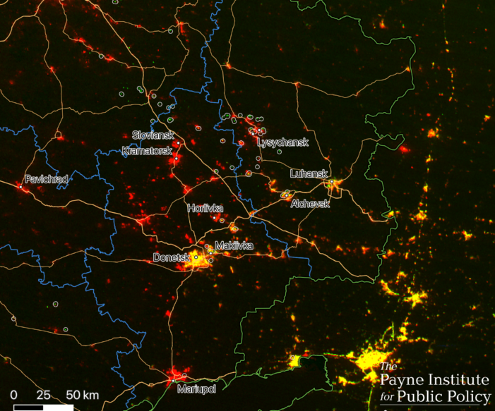
Jun. 6 satellite observations show extensive activities observed along the Donbas frontline, including within the city perimeters of Lysychansk, Alchevsk, Horifika, and Makiivka, while Jun. 8, 2022 satellite images show numerous activities in the Donbas area, mainly in the north of Lysychansk and Sloviansk.
In early June, Earth Observation Group’s satellite images began to show activity within Lysychansk and Sievierodonetsk, two cities separated by the Seversky Donets River in the Luhansk region. The activity grew more intense as Russian forces made gains in Sievierodonetsk, and Zelenskyy described the pair as “dead cities” with as many as 100 Ukrainian soldiers being killed each day.
Jun. 10 satellite images showed intense activities on the Donbas frontline, especially Sievierodonetsk.
In the following days, Russian forces worked to steadily demolish the two cities. In mid-June Russian airstrikes in Sievierodonetsk caused a fire in the Azot chemical plant, where hundreds of Ukrainian citizens and soldiers were sheltering even after Russian forces demanded Ukrainian troops in the chemical plant lay down their arms and surrender.
On Jun. 22 activity remained in the Donbas region, moving south around Sievierodonetsk and Alchevsk.
In late June, after over a month of defending the city, Ukrainian troops retreated from Sievierodonetsk, and the city fell to Russian control in an important victory for the invading country. On Jun. 24 intense activities continued in the Donbas region near Sievierodonetsk , but by Jun. 26 the activities appeared to spread wider across the region.
While the most intensive fighting was in eastern Ukraine, attacks were also observed in other cities across the country. In northern Ukraine, Russia increased its shelling of Kharkiv, killing at least 15 civilians on Jun. 21. A month prior, Ukraine was able to push Russian troops back from the outskirts of the city, but Russia continued its long-range attacks.
A few days later, on Jun. 26, Russia launched air strikes in the capital of Kyiv, which had not been hit with major strikes since early June. One person was killed and six were injured in a Russian strike on a residential apartment building in Kyiv, according to Ukrainian officials. On Jun. 26 activity appeared in Kyiv.
On Jun. 27, after Sievierodonetsk was claimed as a Russian victory, activities around the city lessened but intensified along the previous frontline cities, such as Kharkiv to Sloviansk.
On Jun. 27 a missile strike hit a busy shopping mall in the city of Kremenchuk in central Ukraine. The attack killed many civilians and left others missing, according to Ukrainian officials. Although Russia denied it, Zelenskyy described the attack on the mall as a “calculated” strike. Just a couple of days later, several Russian missiles struck a nine-story apartment building and a resort in the southern port city of Odesa, killing at least 20 people and wounding dozens more.
On Jun. 28 intensive activities continued in the Donbas region around Sievierodonetsk and the frontline from Kharkiv to Horlivka.
Attacks in the Donbas and beyond came as the annual G7 summit began in Germany. Leaders from the world’s seven leading Democratic economies re-emphasized their support for Ukraine. Zelenskyy also spoke with the G7 leaders over video and urged them to approve more military help for Ukraine.
Following their retreat from Sievierodonetsk, Ukrainian soldiers turned their defense to Lysychansk, but just a week later, Lysychansk also fell to Russian forces. Lysychansk was the last remaining Ukrainian-held city in the Luhansk region, and by taking control in early July, Russian forces moved into a better position to capture their next target: the remaining Ukrainian-held parts of the Donetsk region.
On Jul. 1, intensive activities were observed in Donbas frontline, but in the days following the Russian capture of Lysychansk, the activities in Donbas died down and moved further west and south.
On Jul. 6, activities in Donbas area spread further into the southwest region, and areas around Donetsk city started to show more activity.
On Jul. 14, sporadic activities were observed along the southern frontline and in the Donbas area. By Jul. 19, activity increased in southern Ukraine and the Donbas area. Some larger clusters of activity were observed 60 kilometers north of Kherson.
On Jul. 24, intensive activities were observed in Kherson, along with sporadic activities spotted in the Donbas area near Donetsk city.
In July, activity began to pick up in southern Ukraine. While Russian advances have mostly been centered in the Donbas, Ukraine launched a counter attack in Kherson, a city that Russia captured early in the nation’s invasion and has controlled in the months since. The initial capture of Kherson, which sits upon the Dnipro River, allowed Russian forces to continue their westward push toward Odessa, a major shipping hub on the Black Sea. Now backed with Western-supplied arms, Ukrainian forces hope to retake the strategic city.
On Aug. 21, sporadic activities were observed in Donetsk.
Today, Russia continues its onslaught against Ukraine’s determined defenses, and Ukrainian officials have warned that the attacks are expected to worsen in the coming days. It remains to be seen how much longer the fighting will carry on, but with each day bringing more pain and suffering, it will be difficult to call the outcome a “victory” for either side.
ABOUT THE TECHNOLOGY
The Payne Institute’s Earth Observation Group (EOG) has been capturing a unique view of the ongoing conflict in Ukraine using satellite data provided by the Visible Infrared Imaging Radiometer Suite (VIIRS) onboard a Joint Polar Satellite System co-operated by NOAA and NASA. The EOG’s VIIRS Nighttime Lights (VNL) product can display nighttime lights while the group’s VIIRS Nightfire (VNF) product can detect thermal anomalies on the Earth’s surface.
These maps were made with a composite of multiple sources to infer critical information regarding light activity in Ukraine. High moon nights and the location’s proximity to the prime meridian can interfere with the satellite images.
*A note about interpreting the images: The color base illustrates the observed radiance. Red indicates that no lighting was observed for the given night. Yellow indicates the night’s lighting is comparable to the monthly average, and green indicates that new lighting has been observed which was not seen in the monthly average. Blue indicates cloud cover, which may interfere with the observations.
Data from VNF are also added to the map to indicate observations of heat. In most cases the resulting VNF cluster polygons surround new light features in green, which means the observed new lights are resulted from combustion events, such as fires.